National Waterway 1: How the Ganga Became India’s Cargo Artery
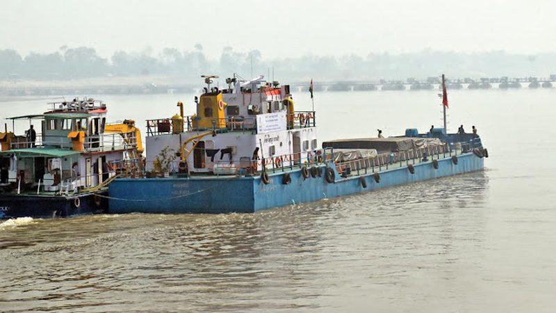
Rivers were India’s original highways: for centuries, boats carried grain, timber and goods along the Ganga. Then railways and roads took over, and inland waterways withered to insignificance. National Waterway 1, the 1,620-kilometre stretch of the Ganga from Prayagraj to Haldia declared a national waterway in 1986, is the centrepiece of the effort to bring cargo back to the river. Under the Jal Marg Vikas Project, backed by the World Bank, the waterway has been developed with modern terminals, assured navigation channels and multimodal connections. Cargo volumes, negligible a decade ago, have grown into the millions of tonnes. This explainer traces how the Ganga became a working cargo artery again.
Why the Ganga suits cargo
The Ganga between Prayagraj and Haldia flows through the Indo-Gangetic plain, the most densely populated and agriculturally productive region in the country, and one of its most industrialised corridors. Coal mines, thermal power plants, steel plants, refineries and foodgrain surplus zones all lie within reach of the river. Water transport’s economics are compelling for bulk cargo: one barge can carry as much as dozens of trucks, at lower fuel cost per tonne-kilometre and far lower emissions. For over-dimensional cargo that cannot move by road, the river is sometimes the only option. The waterway’s natural advantage is geography; its historical disadvantage was infrastructure.
What the Jal Marg Vikas Project built
The project created the infrastructure a modern waterway needs. Multimodal terminals at Varanasi, Sahibganj and Haldia allow cargo to move seamlessly between river, road and rail, with mechanised handling equipment. A new navigational lock at Farakka lets vessels pass the barrage that otherwise blocks the river. Assured depth is maintained through dredging and river-training works, with a target of 2.5 to 3 metres of navigable depth on the busiest stretches. Night navigation aids, vessel traffic management and modern jetties at intermediate points complete the system. The Varanasi terminal, inaugurated as India’s first multimodal river terminal, is the showpiece: containers arriving by river can roll straight onto trucks or rail.
What moves on the river
Coal for power plants was the anchor cargo, moving from the eastern coalfields to upcountry plants. Fly ash, foodgrains, fertilisers, stone chips and containers followed. Trial movements demonstrated the waterway’s range: over-dimensional project cargo for refineries, and even the transport of heavy equipment that roads could not handle. Cargo volumes crossed several million tonnes annually and continue to grow, though they remain small compared to rail and road. The economics work best for bulk, non-urgent cargo over long distances, exactly the profile of coal, minerals and grain.
The challenges of river navigation
Rivers are living systems, and the Ganga is a demanding one. Siltation constantly reshapes the channel, requiring continuous dredging. Lean-season water levels test the assured-depth promise, and the Farakka barrage’s management affects flows downstream. Bridges with low clearances restrict vessel heights on some stretches. Environmental concerns are real: dredging and vessel traffic affect the river’s ecology, including the endangered Gangetic dolphin, and the project has faced scrutiny over its environmental management. Balancing navigation with the river’s ecological and religious significance, this is the Ganga, after all, requires constant negotiation.
The wider waterways push
NW-1 is the flagship, but the Inland Waterways Authority of India has declared over a hundred national waterways, with active development on the Brahmaputra (NW-2), the west coast canal system (NW-3) and others. The vision is a network where rivers and canals carry a meaningful share of bulk freight, cutting logistics costs and emissions. Progress on other waterways has been slower, constrained by water availability, bridges and funding. But NW-1 has proved the concept: with terminals, dredging and assured depth, an Indian river can be a serious cargo carrier. The Ganga, which carried boats for millennia, is carrying them again.
FAQs
How long is National Waterway 1? 1,620 km along the Ganga from Prayagraj (Uttar Pradesh) to Haldia (West Bengal).
What is the Jal Marg Vikas Project? A World Bank-assisted project developing NW-1 with multimodal terminals, a navigational lock at Farakka, dredging and night-navigation infrastructure.
What cargo moves on NW-1? Mainly coal, fly ash, foodgrains, fertilisers, stone chips, containers and over-dimensional project cargo.
The Ganga spent a century as a sacred river that happened to have boats. National Waterway 1 is making it a working river again, one barge at a time, without asking it to stop being sacred.
Source: Press Information Bureau

Khabar 24h Editorial Desk — our explainers are prepared by the Khabar 24h editorial team using AI-assisted research tools, and every piece is reviewed by a human editor before publishing. We do not claim original reporting: our work is turning complex topics into simple, accurate summaries. Spotted an error? Write to contact@khabar24h.com — our corrections policy aims for same-day review.
More from this author →