Atal Setu: Inside the Mumbai Trans Harbour Link, India’s Longest Sea Bridge
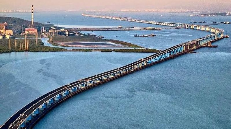
For decades, reaching Navi Mumbai from South Mumbai meant the long detour around the harbour through Thane or the congested Vashi bridge. The Mumbai Trans Harbour Link, officially named Atal Bihari Vajpayee Sewri-Nhava Sheva Atal Setu, ended that: a 21.8-kilometre sea bridge, the longest in India and among the longest in the world, cutting the journey to about 20 minutes. Opened in January 2024, the six-lane bridge is an engineering landmark built over one of the country’s busiest harbour channels, threading between port operations, flamingo habitats and the navigation needs of large ships. This explainer goes inside the bridge: how it was built, what it changes, and what it cost.
The crossing
Atal Setu runs from Sewri in South Mumbai to Nhava Sheva in Navi Mumbai, with about 16.5 kilometres over the sea and the rest on land approaches. The bridge carries six lanes of traffic, with emergency lanes, and is designed for a speed of 100 kmph. It lands near the Jawaharlal Nehru Port, India’s largest container port, and connects directly to the upcoming Navi Mumbai International Airport, making it the keystone of the region’s transport geography. The Mumbai Metropolitan Region Development Authority executed the project, with Japanese financing through JICA covering a large share of the cost, and construction by major Indian and international contractors.
Engineering over the sea
Building a sea bridge in a working harbour meant solving several problems at once. The navigation spans, where large ships pass beneath, use steel orthotropic decks with spans long enough to keep the channel clear. Foundations were sunk through soft marine clay to bedrock, using massive piles. Perhaps the most delicate constraint was environmental: the Sewri mudflats are a wintering ground for flamingos and migratory birds, so construction near the shore used noise and vibration controls, and the alignment was adjusted to protect the habitat. The bridge also had to coexist with port operations, oil pipelines and naval installations. Prefabricated segments were cast in yards and launched over the water, a method that kept the harbour functioning through construction.
What it changes
The time saving is the headline: 20 minutes instead of two hours between South Mumbai and Navi Mumbai. But the deeper effects are economic. The bridge makes Navi Mumbai, with its new airport, port and planned business districts, a genuine extension of Mumbai rather than a distant suburb. Property markets on both sides repriced on opening. Commuters from Raigad district gained practical access to Mumbai’s job market, and port-bound freight got a direct high-speed link. The bridge also relieves the Vashi bridge and the Thane corridors, redistributing traffic across the harbour. Tolls are set at a premium, which sparked debate, but early traffic volumes have been strong.
The cost and the critics
Atal Setu cost roughly 18,000 crore rupees, making it one of India’s most expensive single transport projects. Critics questioned the priority: whether the money might have served Mumbai’s collapsing suburban rail or the city’s flooding better. Environmentalists fought the project through years of litigation over the flamingo habitat and mangroves, extracting mitigation measures but not stopping it. Supporters reply that transformative infrastructure always looks expensive before it opens and obvious afterwards, and that Mumbai’s growth was being strangled by its own geography. The bridge, they argue, is the kind of project a world city builds once a generation.
A bridge into the region’s future
Atal Setu’s full value will emerge as the projects around it complete: the Navi Mumbai airport, the coastal road network, the metro extensions and the JN Port’s expansion. Together they rewire the Mumbai metropolitan region’s centre of gravity eastward across the harbour, a shift planners have dreamed of since the 1970s. Sea bridges are statements of intent, and at 21.8 kilometres, Atal Setu is India’s loudest one yet: a declaration that the country’s financial capital will not be contained by water.
FAQs
How long is Atal Setu? 21.8 km in total, with about 16.5 km over the sea, making it India’s longest sea bridge.
How much time does it save? The Sewri to Nhava Sheva journey drops from around two hours to roughly 20 minutes.
Who built and funded it? MMRDA executed the project with major JICA financing, built by Indian and international contractors.
Atal Setu turned a two-hour ordeal into a 20-minute drive across open water. For Mumbai, a city long defined by its island constraints, that is not just a bridge; it is a new geography.
Compiled by the Khabar 24h Editorial Desk from publicly available sources.

Khabar 24h Editorial Desk — our explainers are prepared by the Khabar 24h editorial team using AI-assisted research tools, and every piece is reviewed by a human editor before publishing. We do not claim original reporting: our work is turning complex topics into simple, accurate summaries. Spotted an error? Write to contact@khabar24h.com — our corrections policy aims for same-day review.
More from this author →